The pinpoint accuracy of the Global Positioning System (GPS) has become an essential part of daily life for everything from navigation to logistics. Whether you’re checking your phone for directions, tracking a delivery, or managing assets, GPS plays a critical role in keeping global supply chains running smoothly.
But GPS is more than just a navigation tool. It supports emergency services, scientific research, precision farming, and disaster relief, among many other applications. With so many possibilities, you might wonder: Am I using GPS to its full potential?
Learning how to use GPS and make the most of it can improve your workflow and enhance productivity. It can even make routine tasks more efficient. If you rely on it for the basics like navigation, security, and monitoring tracked assets, minor optimizations can lead to a better experience. Here are some easy tips and tricks to help you get the most out of GPS technology.
The Science Behind GPS Signals
This guide won’t get too technical, but understanding the basics of GPS is helpful. This short science lesson provides the foundation for learning how to use GPS beyond the basics.
First, the core of GPS capability is a constellation of satellites orbiting Earth. Each transmits signals picked up by receivers on the ground—any GPS-enabled device functions as a receiver. These signals carry data, such as the satellite’s position and the exact time the signal was sent.
The magic behind GPS’s precision lies in the atomic clocks on each satellite. These incredibly accurate clocks ensure the timing information within the signals is precise to within a few nanoseconds. GPS receivers rely on exact timing to calculate accurate distances and their position on Earth.
The Role of Satellite Networks in GPS
While the acronym “GPS” is often used generically, it technically refers to the United States’ Global Positioning System. However, several other Global Navigation Satellite Systems (GNSS) exist, each contributing to a more robust system for every country. Other satellite networks include:
- GLONASS (Russia): Russia’s counterpart to GPS, GLONASS offers similar positioning services.
- Galileo (EU): The European Union’s Galileo offers high-precision positioning and is interoperable with other systems.
- BeiDou (China): China’s independently developed navigation system, BeiDou, provides global coverage and enhances positioning capabilities.
The beauty of some modern GPS receivers is their ability to simultaneously use signals from multiple GNSS networks. By incorporating data from GPS, GLONASS, Galileo, and BeiDou, receivers can access numerous satellites for more accurate, reliable data.
How to Use GPS Effectively
Now that you know the basic workings of GPS and similar GNSS networks, here’s how to use GPS more effectively. These tips will help you optimize your receiver’s performance in various scenarios:
Setting Up and Calibrating a GPS Device
The initial setup of your GPS device is pretty straightforward. However, ensuring a proper setup is critical for optimal performance later. Each part of the process is an opportunity to calibrate and optimize your receiver. Whether you’re using a dedicated GPS device or your smartphone, you can fine-tune the setup at each of these steps:
- Connecting to satellites: When you power on, your device attempts to acquire signals from GPS satellites. It can take a few minutes, especially in areas with obstructions like large buildings or dense foliage. Ensure you’re in a location with a clear sky view for faster signal acquisition.
- Updating maps: Outdated maps can lead to inaccurate directions and subpar performance. Stay current with the latest information, points of interest, and other relevant data by regularly updating the maps on your device or smartphone app.
- Calibrating sensors: Some devices, especially smartphones, rely on additional sensors like compasses and accelerometers to enhance the accuracy of GPS functions. Calibrating these sensors involves a simple on-screen process that can improve the reliability of your location data.
- Checking GPS accuracy settings: Both smartphones and dedicated GPS units often have settings that control GPS accuracy. Familiarize yourself with these settings and set the appropriate accuracy level for your needs. However, higher accuracy settings may consume more battery power, so try to strike the right balance.
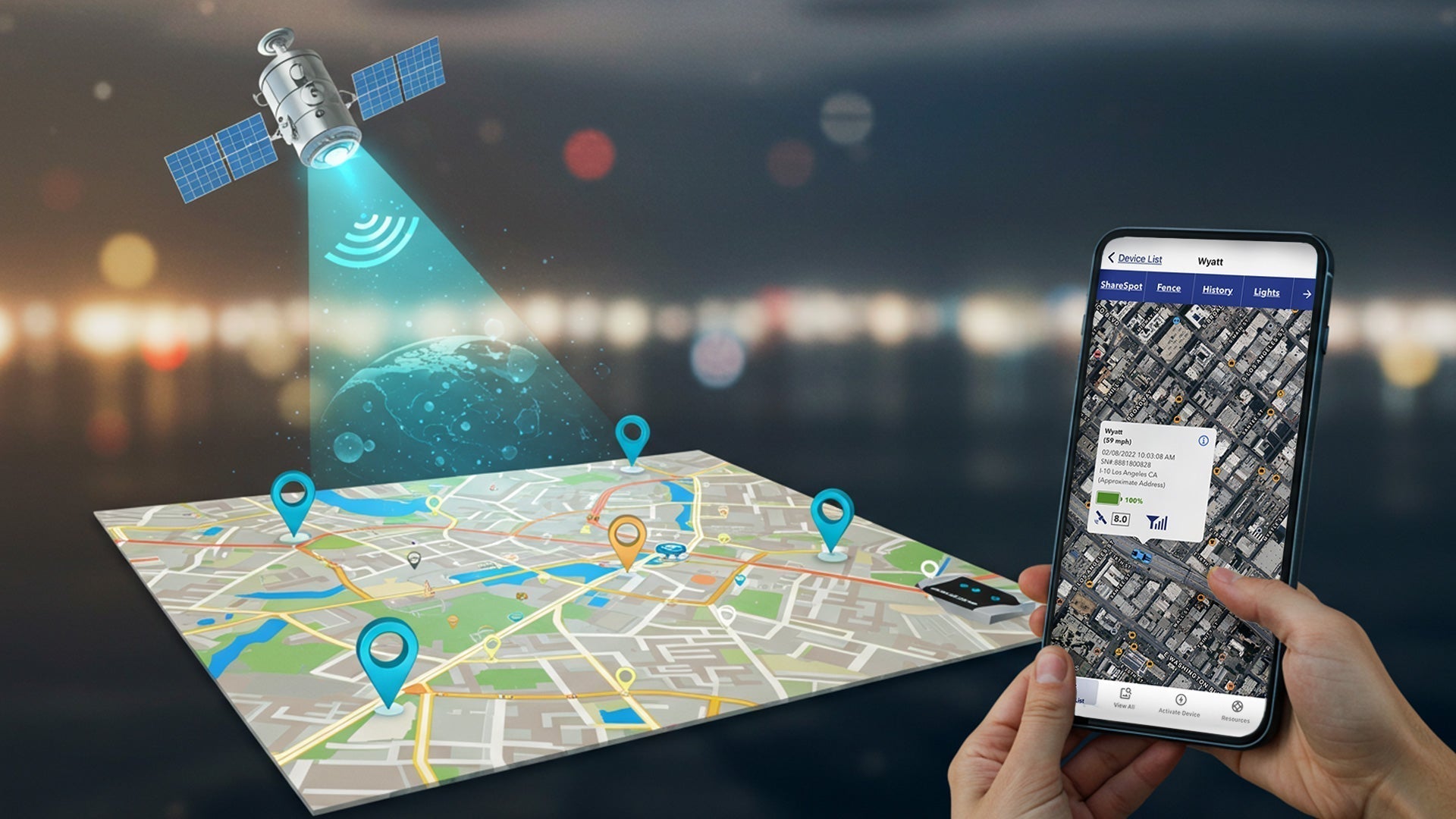
LandAirSea offers GPS tracking through its SilverCloud web portal and mobile app. The web portal provides advanced functionality, including detailed reporting and geofencing, while the mobile app offers a user-friendly interface for on-the-go tracking. Learn more about SilverCloud’s features here.
How to Use GPS for Turn-by-Turn Navigation
Turn-by-turn navigation is arguably the most common use of GPS. Here’s how to make the most of it:
- Input a destination: Enter the address or name of your destination into your GPS device or app. Most systems offer predictive text and address suggestions to speed up the process.
- Interpret the guidance: Pay close attention to GPS’s visual and auditory cues. These cues will guide you through turns, lane changes, and other maneuvers.
- Avoid wrong turns: Follow the directions closely to avoid wrong turns. If you get off course, GPS will automatically recalculate a new route.
- Adjust for traffic conditions: Many modern navigation systems offer real-time traffic updates. Use this information to avoid congested areas and find faster routes.
Using GPS for Offline Navigation
Be prepared for rural or remote areas without internet connectivity. With proper planning and preparation, you can still enjoy full GPS functionality. Here’s how to use GPS offline:
- Download offline maps: Google Maps and similar allow you to download map sections for offline use. Select and download the areas you need before heading out to maintain full navigation capabilities.
- Explore offline GPS apps: Dedicated offline apps are available in your phone’s app store. Explore what’s available for full-featured navigation capabilities when hiking, backpacking, and other outdoor activities.
Creating and Using Waypoints and Routes
Waypoints and routes are features often overlooked in GPS devices and apps. Here’s how they can enhance your GPS experience:
- Setting and saving waypoints: Waypoints are specific locations you mark on your map. You can save waypoints for places of interest, campsites, or any location you like.
- Creating custom routes: Combine multiple waypoints to create custom routes for activities like biking and boating. Most GPS devices and apps let you plan and follow routes during your trip.
- Using routes for outdoor activities: Routes help you stay on track and estimate travel times. They’re invaluable in areas with limited trails or challenging terrain.
How to Use GPS for Safety and Emergency Situations
Beyond navigation and asset tracking, GPS is a valuable safety and emergency preparedness tool. Here’s how to leverage GPS features for critical situations when seconds can make a difference:
- Sending SOS signals: Some GPS devices and smartphones have built-in SOS functions. Activating this feature sends a distress signal and your current location to selected friends and family. If you can’t make a phone call, it can get you out of a predicament and even save your life.
- Live location sharing: Many messaging and dedicated safety apps offer live location sharing, so friends, family, or emergency services can track your movements and determine your location. If you’re hiking or just enjoying nature, for example, and get lost or have an accident, you’ll know someone can find you.
- GPS distress beacons: Sometimes called personal locator beacons or PLBs, GPS distress beacons are GPS devices with one purpose: transmitting a distress signal to search and rescue authorities via satellite, even when out of cellular range. These beacons simplify calling for help in remote areas and help ensure your safety.
- Geofencing alerts: Geofencing allows you to define virtual boundaries on a map. While often used for alerts when a tracked asset enters or exits a specific area, geofencing is also used for monitoring children or elderly family members.
Factors That Affect GPS Accuracy
GPS is remarkably accurate, but it’s not infallible. Inaccurate GPS data can lead to frustrating lapses in functionality or even risk your safety if you depend on your device for emergency services.
But what affects GPS accuracy? Here are some of the most common causes.
Satellite Positioning
The geometry of GPS and GNSS satellites relative to the receiver determines how well a GPS device receives the signal. When satellites spread out across the sky, accuracy is high. If satellites cluster in one area, GPS accuracy drops.
Atmospheric Conditions
Earth’s atmosphere can delay and distort GPS signals. Weather patterns and solar activity can negatively affect signal propagation, leading to inaccuracies. Changes in the ionosphere and troposphere can also disrupt GPS signal transmission.
Obstructions
Physical obstructions, such as tall buildings, dense forests, tunnels, or heavy foliage, can block and weaken GPS signals. Depending on the obstruction, your receiver might suffer from signal reflections, signals bouncing off surfaces, or even complete signal loss. That’s why physical obstructions are a common cause of inaccurate GPS data.
Signal Interference
Radio frequency interference from other electronic devices — including mobile phones, stereo equipment, and Wi-Fi routers — can disrupt GPS signals. This interference can corrupt the data received by the GPS receiver, resulting in inaccurate positioning.
GPS For Different Use Cases: Best Practices and Recommendations
Knowing how to use GPS includes following best practices for your specific use case. Here are a few common scenarios and ways to maximize your use of GPS.
Using GPS for Driving and Road Navigation
Efficient road navigation relies heavily on accurate, timely GPS data. Before you get on the road, you can take some precautions.
First, input your destination and review the suggested route. Consider alternative routes, especially during peak traffic hours. Familiarize yourself with the route overview to anticipate upcoming turns and intersections.
Next, if your GPS device or app provides real-time traffic updates, enable this feature. These user-submitted updates can help you avoid congested areas and find faster routes. Be flexible and willing to adjust your route based on traffic conditions.
Finally, remember that GPS isn’t foolproof. Recent changes, like construction detours, can mean outdated maps. Signal issues can also lead to inaccurate directions. Trust what you see in front of you over what GPS tells you. Always pay attention to road signs and surroundings, and don’t unquestionably trust GPS instructions.
Using GPS for Hiking and Outdoor Adventures
When hiking or exploring off-road, use up-to-date topographic maps in addition to your GPS device. Topographic maps provide detailed information about terrain, elevation, and trails, which is critical for safe navigation.
Also, consider carrying a GPS distress beacon for outdoor adventures deep in nature. A direct connection to search and rescue authorities via satellite can be a lifesaver, even when out of cellular range.
GPS for Personal Security and Safety
Many personal safety apps and GPS devices include emergency alert features. These features allow users to quickly send a distress signal and location to select contacts or emergency services.
The LandAirSea family of products offers solutions suitable for various personal safety needs. These compact, discreet GPS trackers can be used for child tracking, senior monitoring, or personal emergency alerts. SilverCloud provides real-time location data and geofencing capabilities for effective monitoring and quick emergency responses.
Choosing the Right GPS Device for Your Needs
The best way to use GPS is to buy a device that meets your specific requirements. Unfortunately, it’s not a straightforward process, as the world of GPS devices is vast and varied. But even with the many available options, you can still narrow them down and get the tracker that’s right for you.
Key Features to Look for in a GPS Device
Regardless of your unique needs, these features are essential for any GPS device:
- Accuracy: The most fundamental feature is consistent accuracy. Look for devices that support multiple GNSS constellations for maximum reliability.
- Real-time tracking: For fleet management or asset monitoring, real-time tracking is essential. You’ll get up-to-the-minute location information to monitor movements and respond quickly to critical events.
- Geofencing: After defining virtual boundaries, you’ll receive alerts when a device enters or exits that area. Geofencing monitors children, elderly family members, or valuable assets such as vehicles.
- Battery life: Choose a device with ample battery life to avoid frequent recharging or replacing cycles.
- Waterproof rating and durability: Waterproof rating is a concern if you use a GPS device outdoors or in harsh environments. Look for devices with a high IP (ingress protection) rating to ensure they can withstand the elements.
- Mapping and navigation: Ensure the device can access accurate, updated maps. Consider features like turn-by-turn directions, route planning, and points of interest.
- Connectivity: Some GPS devices use cellular networks for real-time tracking, while others rely on satellite communication for remote areas.
Budget vs. Premium GPS Devices: What’s Worth the Investment?
As you shop for GPS devices, you’ll likely notice a wide range of price points. What makes one tracker cost more than another, and is it really any better? The answer depends on the features and performance of budget and premium GPS products.
Budget devices typically offer only essential GPS functionality, such as location tracking and navigation. They may have shorter battery life, less frequent update rates, and lower accuracy than more expensive devices.
On the other hand, premium devices typically offer real-time tracking, geofencing, longer battery life, durable designs, and higher accuracy. They may also have nice extras like topographic maps, satellite communication, or integration with other electronic devices. In general, higher-end devices are worth the investment for professional use. However, premium GPS devices are often worthwhile for demanding personal applications or situations where accuracy and reliability are absolutely required.
LandAirSea GPS Solutions: Reliable Tracking for Every Need
LandAirSea is a trusted provider of GPS tracking solutions for nearly any scenario or application. That’s because our diverse product range reflects our commitment to accuracy, rugged design, reliability, and ease of use. Now that you know how to use GPS effectively, find the solution that meets your needs by checking out the complete lineup of LandAirSea products.