Everything You Need To Know About How GPS Tracking Works
GPS technology has evolved significantly since its creation in 1973. Today, users benefit from 32 dedicated satellites that orbit Earth. These satellites send signals to receivers and base stations on the planet’s surface. That’s how global navigation satellite systems (GNSS) function. But how GPS tracking works is a little bit different. In fact, it requires more sophisticated digital technology, either built into GPS tracking systems or accessible through mobile applications. In this article, we are going to go over some of the things you need to know about a GPS device tracks the location of an asset or vehicle and breakdown the process of how GPS tracking works!
![]()
How a GPS Tracking System Does Its Job
At the most basic level, GPS works by:
- Satellites send signals to the Earth’s surface.
- Ground stations receive signals and send the information to a master control station.
- Master control stations determine whether satellites need repositioning, and they send repositioning instructions to ground-based antennae.
- Antennae send instructions to satellites to maintain accuracy.
- Receivers use satellite signals to calculate three-dimensional locations.
GPS tracking systems must do more than identify a device’s location. They must continuously follow the device to show current and historical location data.
Basic GPS chips found in cell phones, smartphones, and stand-alone GPS trackers can use trilateration to calculate precise locations. Tracking an item, however, typically requires sophisticated software. Your device might ping its location to the software on a pre-set schedule. The software uses that information to create a real-time path that shows the device’s movements.
Cellular and GPS data can work together to create a more insightful, accurate map. Even if you lose your cellular connection, the GPS device can send data to the software when it reconnects.
GPS Trilateration
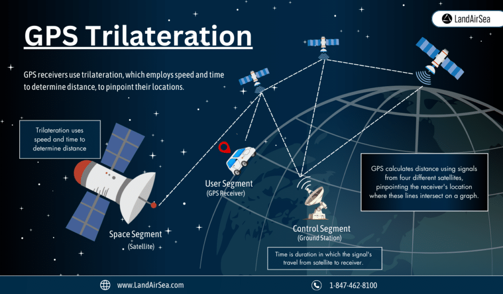
GPS receivers use trilateration to determine their locations. It’s a pretty simple concept, but it takes amazing precision to execute in the real world.
Trilateration uses speed and time to determine distance:
Distance = Speed * Time
GPS uses radio signals that travel at 299,792.458 kilometers per second. Time equals the amount of time it takes for the signal to travel from the orbiting satellite to the receiver. Let’s say it takes .00836090 seconds for the signal to travel from the satellite to the receiver.
With that information, you will find that the distance between the satellite and the receiver equals 2506.5347620922002534 kilometers.
Receivers perform this calculation four times, each using a different satellite’s signal.
The results create a graph of lines that all intersect in one place. That’s the receiver’s location.
The U.S. Space Force’s GPS website has a trilateration exercise that uses colored strings. Visit the site to try the exercise.
Trilateration and GPS Tracking
GPS tracking involves a lot more computing power than calculating a single location. GPS devices with tracking features must perform these calculations constantly. This process essentially creates a series of locations. When you connect those dots, you get a line that shows the GPS tracker’s location.
What Is a GPS Satellite – The Space Segment
GPS satellites transmit radio waves to the Earth’s surface. Each satellite has a unique signal that tells ground stations and receivers where it is located and when the signal was sent. These signals are used by trilateration to calculate locations on the surface.
Since the program started in 1973, the U.S. government has successfully launched 76 GPS satellites into orbit. However, only 32 of those satellites are still operating and orbiting the planet. The Department of Defense plans to launch 22 more satellites soon, but it hasn’t released a timeline for when those launches will occur.
What Do GPS Satellites Transmit?
GPS satellites transmit encoded radio signals that include several pieces of information for civilian (L2C) and military (M-Code) use. The signals also contain information that helps GPS ground stations reposition satellites for improved improved accuracy.
Some of the most important data packets transmitted by GPS satellites include:
- An alert that tells ground stations and receivers not to trust a satellite’s information, making it possible for ground stations to detect operational issues and disregard the satellite’s data packets within 12 seconds of a malfunction.
- Redundant location information to help ensure accuracy at the local level.
- The current time (each satellite contains several atomic clocks to ensure accuracy).
Not much information has been released about the military signals, but they have looser parameters that let the military transmit data packages containing practically any information users want to include.
The GPS Satellite Blocks
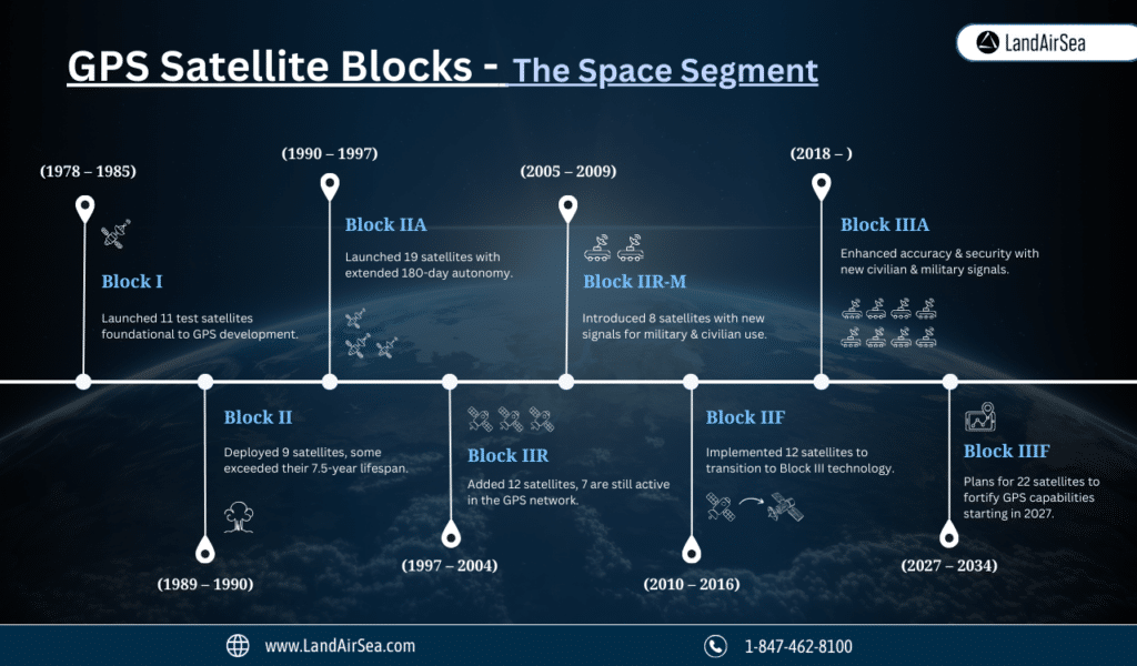
GPS satellites are grouped into “blocks” that represent improvements in technology.
Block I (1978 – 1985)
- Between 1978 and 1985, 11 satellites manufactured by Rockwell International were launched. Only one failed.
- The Block I satellites were intended to test GPS concepts and functionalities.
- None of the Block I satellites currently participate in GPS, but they were critical to building the modern system.
Block II (1989 – 1990)
- Nine satellites manufactured by Rockwell International were successfully put into orbit between 1989 and 1990.
- In addition to systems essential for global positioning, the satellites carried sensors that could detect nuclear detonations.
- None of the Block II satellites currently contribute to GPS.
- The satellites were expected to have 7.5-year lifespans, but one of them was still operational in 2007 when the Department of Defense retired it from service.
Block IIA (1990 – 1997)
- Nineteen satellites were successfully launched and put into orbit between 1990 and 1997.
- The satellites in Block IIA could operate for 180 days without assistance from ground stations. The previous block’s satellites could only last 14 days.
- None of the Block IIA satellites play roles in the current GPS system.
Block IIR (1997 – 2004)
- The Block IIR satellites were replacements developed by Lockheed Martin.
- The first launch failed when a rocket exploded 12 seconds after launch.
- The 12 successful launches still orbit the planet, and seven participate in modern GPS.
Block IIR-M (2005 – 2009)
- Block IIR-M is a group of eight satellites manufactured by Lockheed Martin.
- The Block IIR-M series satellites added military signals and a civilian L2C signal (1227.6MHz) to the system.
- All but one of the satellites are healthy and in orbit.
Block IIF (2010 – 2016)
- Block IIF consists of 12 satellites manufactured by Boeing.
- These satellites were intended to help the system transition from the original NAVSTAR models to Block III technology.
- All 12 Block IIF satellites are healthy and orbiting the planet.
Block IIIA (2018 – )
- Block IIIA satellites play a greater role in civilian use than in previous generations.
- The Block IIIA satellites use two civilian signals to eliminate ionospheric delays that can disrupt location accuracy.
- The satellites also use a new military signal (M-code) that improves security and resists jamming.
- The first Block IIIA satellite was launched in 2018. So far, six satellites have been put into orbit. Four more launches are planned between June 2024 and the end of 2026.
Block IIIF (2027 – 2034)
- The United States Air Force plans to start launching Block IIIF satellites manufactured by Lockheed Martin in 2027.
- The plan currently includes 22 satellites that should be in orbit by 2034. The first two satellites are in production.
What Is a GPS Ground Station – The Control Segment
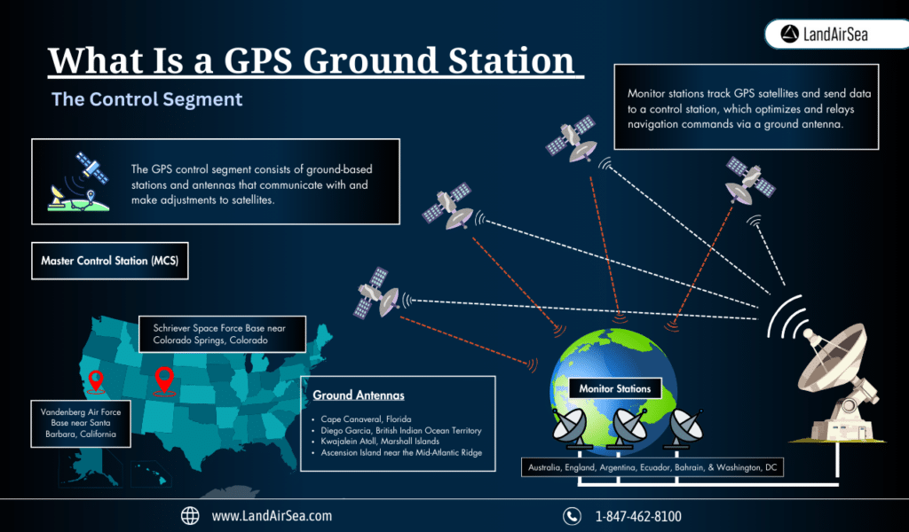
Satellites play a pivotal role in GPS technologies, but you can’t begin to discuss how GPS tracking works without also mentioning the control segment. The GPS control segment consists of ground-based stations and antennas that communicate with and make adjustments to satellites. The ground-based system currently includes:
- A master control station (MCS) located at Schriever Space Force Base near Colorado Springs, Colorado
- An alternative MCS located at Vandenberg Air Force Base near Santa Barbara, California
- Four dedicated ground antennas are located at Cape Canaveral, Florida; Diego Garcia, British Indian Ocean Territory; Kwajalein Atoll, Marshall Islands; Ascension Island near the Mid-Atlantic Ridge
- Six dedicated monitor stations located in England, Argentina, Ecuador, Bahrain, Australia, and Washington, DC
The monitor stations track GPS satellites and receive signals to collect data about them. The data is transmitted to the master control station, which coordinates information from the monitor stations, accuracy tests, and generates navigation instructions to optimize the satellite constellation. The master control station then sends its commands to a ground antenna that communicates instructions to the satellites.
What Is a GPS Receiver – The User Segment
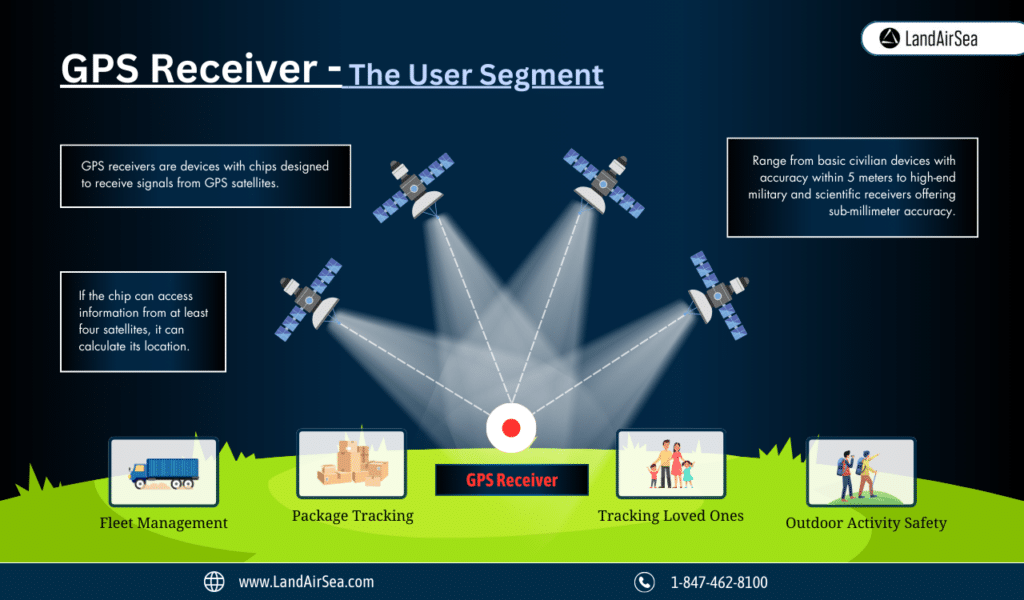
Now that we understand how satellites and ground stations play a role in how GPS tracking works, let’s explore the final piece of the puzzle: GPS receivers. The user segment includes a broad range of GPS receivers, including military, scientific, and civilian devices. These devices contain chips designed to receive signals from GPS satellites. If the chip can access information from at least four satellites, it can calculate its location.
The accuracy of GPS receivers varies depending on their technology. For example, a smartphone might only give you accuracy within 5 meters. A high-end receiver used in scientific research and military operations could provide sub-millimeter accuracy.
Civilians and businesses often use GPS receivers to:
- Manage commercial vehicle fleets
- Track packages
- Manage vehicle dealership inventories
- Protect loved ones, especially children and the elderly, who might get lost
- Get efficient driving directions
- Protect assets from theft
How Businesses Use GPS Asset Tracking
Asset tracking has become essential to many businesses. Many use GPS to:
- See the current locations of expensive assets
- Track company vehicles and monitor driving habits
- Receive notifications when assets move
- Monitor vehicles to make fleet management more effective and efficient
Families and Individuals Use GPS Tracking Devices Too
The U.S. government gave civilians access to the global positioning system in the 1980s. Since then, people have found countless ways to benefit from the technology. Individuals and families often use GPS receivers to:
- Track the locations of loved ones, especially children and older adults
- Monitor teen driver behavior
- View vehicle locations to prevent theft and experience peace of mind
- Prevent thieves from stealing high-value items
- Improve safety while hiking, camping, and traveling
FAQ
How accurate are GPS trackers?
Anywhere from 5 meters to less than a millimeter! GPS units rely on a network of satellites that orbit the planet twice daily. Your GPS tracker works best when it has a line of sight to at least four satellites. Unfortunately, tall buildings, thick clouds, and other obstructions can degrade accuracy. Also, devices that use multiple signal types can often overcome the challenges created by barriers. Therefore, we would encourage you to look for units that can connect to cellular networks (4GLTE) and GPS satellites (GNSS).
Want to learn more about the accuracy of GPS navigation system or asset tracking device? Then check out this article: https://landairsea.com/how-accurate-are-gps-unit-coordinates-really/
Is it legal to track someone’s vehicle?
GPS tracking laws vary from state to state. Most states allow owners to track their vehicles, though you might need consent from the driver. If you want to learn more about the specific laws in each state, check out this article. However, if you want the most relevant information regarding GPS laws then we would encourage you to contact an attorney in your area of intended use before using a vehicle or asset tracker.
Do smartphones work as well as stand-alone GPS trackers?
No, smartphones are not designed to act as a stand-along tracking solution. Why? They do not use satellite tracking technology, but rather cellular triangulation. Basically, this means cell towers are aiding in locational information, not true GPS technology. This makes smartphones less accurate and less reliable for applications related to fleet tracking, or in personal safety situations like medical alerts.