Everything You Need To Know About Who Invented GPS

You probably use the Global Positioning System (GPS) daily to get driving directions or anticipate a delivery time. Somewhat surprisingly, this ubiquitous technology has only been available to civilians since the 1980s. Before then, the American armed forces retained exclusive rights to global positioning. Given that you probably use GPS daily, you might have wondered, “Who invented GPS?” The answer includes a list of people who contributed essential concepts to the system’s development.
Navigation Before GPS
Using satellites to pinpoint a location on the Earth’s surface wasn’t a new idea when the U.S. started working on Navstar GPS. American physicists realized the potential shortly after Russia launched its first satellite, Sputnik.
William Guier and George Weiffenbach used equipment at John Hopkins University’s Applied Physics Laboratory (APL) to monitor radio signals from Sputnik. They also realized they could use the Doppler Effect to determine Sputnik’s location. It required massive computing power for the time, but they made it work.
Soon, APL asked the pair whether they could reverse the process to determine a location on the planet. The results were particularly interesting to the U.S. Navy, which needed to know precise locations to launch missiles from submarines. Research contributed to the Defense Advanced Research Projects Agency (DARPA), which continues investing in essential technologies.
Ivan Getting, Bradford Parkinson, and Roger Easton
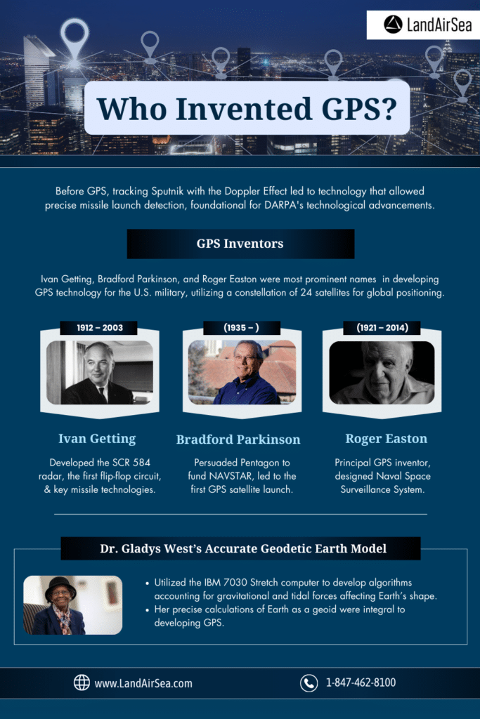
Early satellite systems benefited the U.S. military, but they didn’t offer as much information as today’s GPS. The U.S. Department of Defense wanted a better system, so it hired three experts to develop the technology. Yes, when it comes to who invented GPS, several key figures played a significant role in the development of GPS technology. Some of the most prominent names are Ivan Getting, Bradford Parkinson, and Roger Easton.
The group made plans for a global positioning system that relied on 24 satellites orbiting the planet that communicate with ground-based GPS receivers. Their strategy included ideas from general relativity, radio-navigation systems built in the 1940s, and Gladys West’s mathematical geodetic Earth model.
The first group of satellites were put into orbit between 1978 and 1985. Six additional blocks of satellites have been added. The system currently has 38 satellites in orbit, but only 32 are operational.
Ivan Getting (1912 – 2003)
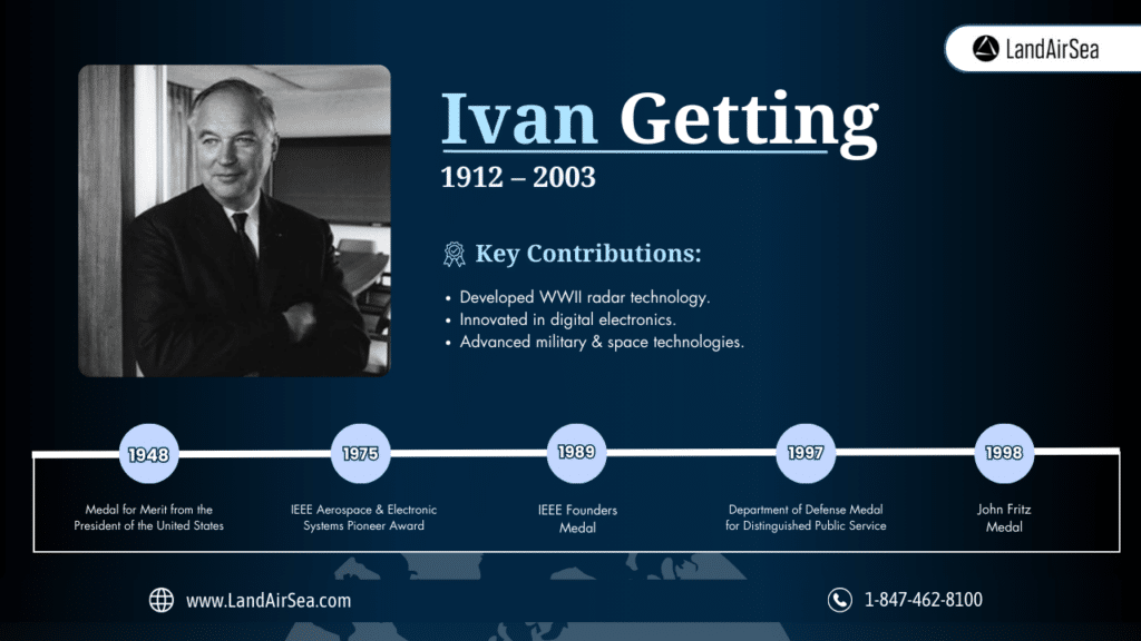
Quick facts about Ivan Getting:
- Worked with a group at MIT that developed the SCR 584, the first automatic microwave tracking fire control radar, which helped protect London from V-1 bombs during WWII.
- Helped develop the first flip-flop circuit, a foundational concept that contributed to integrated circuits and digital electronics.
- Contributed to several military technologies, including the Hawk and Sparrow III missile systems.
- His work at The Aerospace Corporation contributed to the launch systems used Mercury and Gemini space programs.
Ivan Getting’s major awards include:
- Medal for Merit from the President of the United States (1948)
- IEEE Aerospace and Electronic Systems Pioneer Award (1975)
- IEEE Founders Medal (1989)
- Department of Defense Medal for Distinguished Public Service (1997)
- John Fritz Medal (1998)
Bradford Parkinson (1935 – )
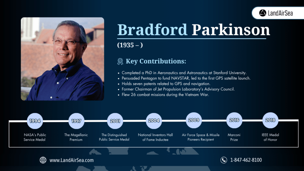
Quick facts about Bradford Parkinson:
- Earned a Bachelor of Science in Engineering from the United States Naval Academy.
- As a commissioned officer, the United States Air Force paid for him to earn a Master of Science in Aeronautics and Astronautics from MIT.
- Holds seven patents related to GPS, navigation, and vehicle control.
- Completed a PhD in Aeronautics and Astronautics at Stanford University.
- Taught classes for astronauts who would join NASA’s space flights.
- Worked as a professor and the Deputy Head of the Air Force Academy Department of Astronautics and Computer Science.
- Flew 26 combat missions during the Vietnam War, logging more than 170 combat hours.
- Served as the Head of the Department of Astronautics and Computer Science at the Air Force Academy.
- Convincing The Pentagon to fund the NAVSTAR project, which led to the launching of the first GPS satellite.
- Former Chairman of Jet Propulsion Laboratory’s Advisory Council.
- The National Executive Committee for Space-Based PNT Advisory Board co-chair.
Bradford Parkinson’s major awards include:
- NASA’s Public Service Medal (1994) and Distinguished Public Service Medal (2001)
- IEEE’s Kershner Award (1986), Pioneer Award (1994), M. Barry Award (1998), and Simon Ramo Award (2002)
- The Magellanic Premium, with Roger Easton (1997)
- National Inventors Hall of Fame inductee (2004)
- Marconi Prize (2016)
- Air Force Space and Missile Pioneers recipient (2009)
- IEEE Medal of Honor (2018)
Roger Easton (1921 – 2014)
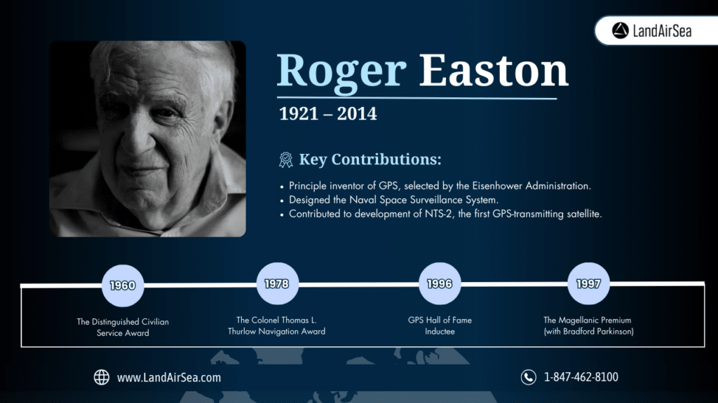
Quick facts about Roger Easton:
- Considered the principle inventor of GPS because the Eisenhower Administration selected his proposal over two others.
- Designed the Naval Space Surveillace System, the first technology capable of tracking all objects orbiting the planet.
- Contributed ideas that led to the development of NTS-2, the first satellite that could transmit GPS signals.
- Easton ran an unsuccessful 1986 campaign to become New Hampshire’s governor.
Roger Easton’s major awards include:
- The Distinguished Civilian Service Award (1960)
- The Colonel Thomas L. Thurlow Navigation Award from the Institute of Navigation (1978)
- GPS Hall of Fame inductee (1996)
- The Magellanic Premium, with Bradford Parkinson (1997)
Dr. Gladys West’s Accurate Geodetic Earth Model
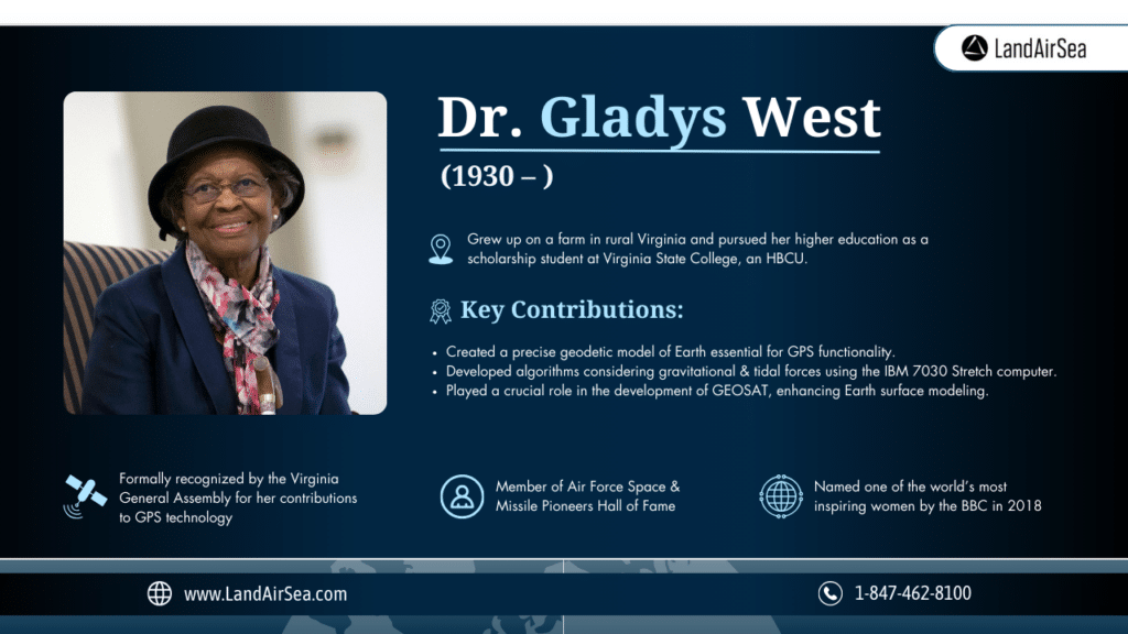
Gladys West didn’t invent GPS, but she did create an accurate model of the planet that makes GPS functional. Most of the time, you probably think of Earth as a basic globe. That’s accurate enough for daily life, but Dr. West wanted to create a much more accurate model.
After becoming her high school’s valedictorian, West pursued mathematics at Virginia State College, a historically black college or university (HBCU). She earned her bachelor’s and master’s degrees at the school. In the 1970s, she used an IBM 7030 Stretch computer to test algorithms she’d written. Her algorithms considered factors like gravitational and tidal forces, which can influence the planet’s shape.
Over time, her calculations become increasingly precise. Her algorithms so accurately reproduced Earth as a geoid that the calculations were used when developing the Global Positioning System. She later received her PhD from Virginia Tech. She completed the program via distance learning.
West’s work has made a member of the Air Force Space and Missile Pioneers Hall of Fame. She’s also hailed as a “hidden figure” who wasn’t given appropriate acknowledgment because she was a black woman. Her scientific contributions have been more widely profiled in recent years.
Quick facts about Dr. Gladys West (1930 – )
- Grew up on a farm in rural Virginia.
- Won a scholarship to attend the historically Black college Virginia State College, now known as Virginia State University.
- Holds bachelor’s and master’s degrees in mathematics from Virginia State College.
- Was one of the first Black employees at the U.S. Naval Proving Ground.
- Met her husband, mathematician Ira V. West, at the U.S. Naval Proving Ground.
- Worked on the Naval Ordinance Research Calculator to track the movements of Neptune and Pluto.
- Became a project manager for Seasat, a satellite designed to collect data about factors like water temperature, wave heights, and icebergs.
- Seasat led to the GEOSAT program that developed a satellite capable of creating an accurate computer model of the planet’s surface.
- Holds a PhD in public administration from the University of Oklahoma.
- Her contributions to GPS technology have been formally recognized by the Virginia General Assembly.
- She’s a member of the Air Force Space and Missile Pioneers Hall of Fame.
- The BBC named her as one of the world’s most inspiring women in 2018.
Learn more about GPS tracking accuracy here: https://landairsea.com/how-accurate-are-gps-unit-coordinates-really/
GPS Technology Keeps Progressing
Over the years, GPS technology has become increasingly precise. Most consumer products, including smartphones, are accurate within 5 meters. Wi-Fi positioning, however, can improve accuracy. In fact, some high-end GPS receivers offer accuracy within less than a millimeter!
The future of GPS applications will likely include:
- Location-based marketing that targets consumers near stores, restaurants, and other businesses
- Improved drone accuracy
- Smart cities that use sensors and location data to adapt to transportation needs
Contact our office to learn more about LandAirSea products and data plans. We have options for individuals, businesses, and governments.
FAQs
Did a Black woman invent GPS?
Gladys West, a Black mathematician born in 1930, developed algorithms that correctly map the Earth’s shape. When people ask “Who invented GPS?”, her contributions are frequently noted as being an intricate part of the collective genius of physicists and engineers who invented GPS technology.
Did the U.S. military build the Global Positioning System?
The U.S. Department of Defense built the original GPS system, but civilians gained access in 1983. Today, the United States Space Force operates the system.
When was GPS invented?
The development of GPS started in 1973. The system wasn’t fully functional until 1995, when the program put the last of 24 nominal satellites in orbit. The system currently includes 32 operational GPS satellites.