When most people first see a pair of GPS coordinates, they’re left scratching their head trying to figure out what all those degrees and decimals mean before you know how to read coordinates. Fortunately, once you have a basic understanding of the geographical lines known as latitude and longitude, you’ll be able to ready any of the three GPS coordinate formats with ease.
How GPS Navigation Works
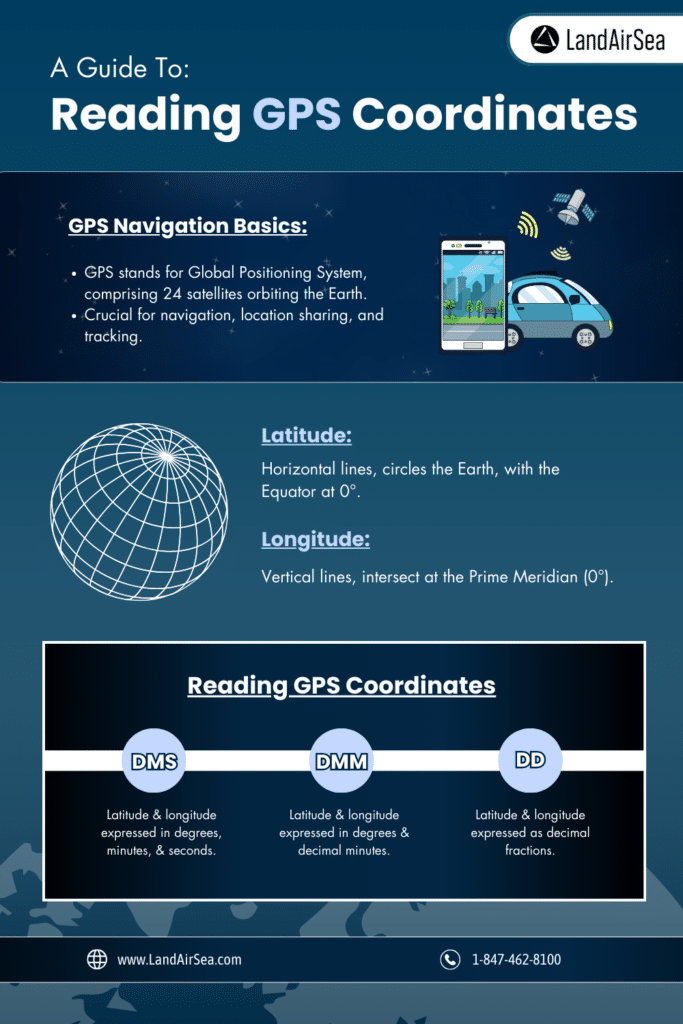
GPS stands for Global Positioning System, which is a network of 24 manufactured satellites that orbit the earth. Using GPS, you can pinpoint an exact location anywhere on the earth, which is why GPS is considered the most accurate tool for navigating and tracking.
The Department of Defense (DOD) approved the modern GPS constellation in 1973 and began launching satellites just five years later. The system became fully operational in 1993. To this day, the DOD uses it to help with everything from directing missiles to helping the military get around in unfamiliar territory. Civilians have also been able to use GPS for more than 30 years now, which has proven extremely beneficial.
Devices communicate with GPS satellites using low-powered radio waves. Thanks to their precise placement and the incredible speed at which they travel, that instant communication allows us to accurately pinpoint any location in the form of GPS coordinates.
Learn more about how GPS works here: https://landairsea.com/blog/where-is-the-best-place-to-hide-a-gps-tracker/
Lines Of Latitude And Longitude
Before you can read a pair of GPS coordinates, you must first understand the relationship between latitude and longitude. These geographical lines circle the globe vertically and horizontally creating the Equator and Prime Meridian, and providing us with a grid that we can use to pinpoint any location.
Latitude
Latitudinal lines, or “parallels,” divide the earth into segments. Lines of latitude run from east to west, going all the way around the globe. The Equator is positioned at the midsection of the earth, which is its widest point. This makes the Equator the longest line of latitude and it also acts as our primary reference, which is why we say the equator is located at 0° latitude.
When determining the coordinates of a location, you’ll start by tracing it either north or south of the equator. In either direction, each line of latitude adds 1° to your coordinates. North or south is typically marked with an “N” or an “S,” respectively. So, the Equator is the primary line at 0° latitude, while the North Pole sits at 90° N and the South Pole sits at 90° S.
Longitude
Longitudinal lines, or “meridians,” divide the earth similarly to latitudinal lines, except longitudinal lines run the vertical length of the earth, stretching from north to south. Just as the Equator is located at the widest horizontal stretch of the earth at 0° latitude, the Prime Meridian is located at the largest vertical stretch of the earth at 0° longitude.
To find the other half of your coordinates, you’ll start by tracing either east or west of the Prime Meridian. In either direction, each line of longitude adds 1° to your coordinates. East or west is typically marked with an “E” or an “W,” respectively. So, the Prime Meridian is the primary line at 0° longitude, with meridians wrapping all the way around to 115° E and 115° W.
Reading GPS Coordinates
By merely drawing a “grid” on the earth using the lines of latitude and longitude, you can create a pair of GPS coordinates to pinpoint any location with great precision. The order is simple: Latitude always comes first. So, 20° N, 50° W means the location is 20 degrees north of the Equator and 50 degrees west of the Prime Meridian.
Unfortunately, most GPS coordinates feature more than two numbers, and that’s because most locations don’t align perfectly with the 1° intervals of latitude and longitude. To create the precision we’ve been talking about, each line is further divided–and to make matters a bit more confusing, there isn’t one standard system for dividing the lines, there are actually three ways to write GPS coordinates.
As we go through these, it’s important to note that some coordinates use positives and negatives instead of N, E, S, and W. For latitude, positive would represent North and negative would represent South. For longitude, positive would represent East and negative would represent West.
Degrees, Minutes, And Seconds (DMS)
Degrees, minutes, and seconds (DMS) is a format that divides the space between each line of latitude or longitude into 60 minutes and divides each minute into 60 seconds. This concept can seem confusing because it associates coordinates (which are unchanging) with time, but it’s a very common system.
In this format, the coordinates of the Eiffel Tower are 48°51’30.24″N, 2°17’40.2″E. You’d read these coordinates as 48 degrees, 51 minutes, 30.24 seconds north and 2 degrees, 17 minutes, and 40.2 east.
Degrees And Decimal Minutes (DMM)
Degrees and decimal minutes (DMM) is another format that can be used to express GPS coordinates. It divides the space between each line of latitude or longitude into 60 minutes and divides each minute into decimals.
In this format, the coordinates of the Eiffel Tower are 48° 51.504′ N, 2° 17.67′ E. You’d read these coordinates as 48 degrees, 51.504 minutes north and 2 degrees, 17.67 minutes east. Without counting minutes and seconds separately, these coordinates roll off the tongue with a bit more ease, but this is actually the least common format for displaying GPS coordinates.
Decimal Degrees (DD)
Decimal degrees (DD) is the third, simplest, and perhaps most common format for expressing a pair of GPS coordinates. This format divides the space between each line of latitude or longitude into 60 decimals, avoiding the confusion of minutes or seconds, although it can result in a long fractional portion.
In this format, the coordinates of the Eiffel Tower are simply 48.8584 N, 2.2945 E. You’d read these coordinates as 48.8584 degrees north and 2.2945 degrees east. With no minutes or seconds at all, these coordinates are, by far, the easiest to communicate.
Using A GPS For Tracking And Navigation
Learning how to read GPS coordinates is important, especially if you plan to use a GPS device to navigate to a location, share your own location, or track the location of a person or asset. If you need help finding reliable GPS equipment to help, browse LandAirSea’s catalog of professional GPS equipment and find the product that fits your needs.